Shulph Ink
rolled,British Isles Communication
rolled,British Isles Communication
💎 Earn 43 Points (£0.43) on this item.
YOU SAVE £3.22
- Condition: Brand new
- UK Delivery times: Usually arrives within 2 - 3 working days
- UK Shipping: Fee starts at £2.39. Subject to product weight & dimension
Bulk ordering. Want 15 or more copies? Get a personalised quote and bigger discounts. Learn more about bulk orders.
Couldn't load pickup availability
- More about rolled,British Isles Communication
Format: Sheet map, rolled
Publication date: 08 May 2019
Publisher: Ordnance Survey
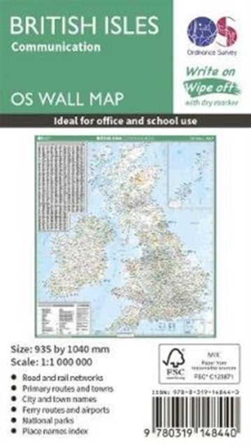
This map shows the British isles, with all the major road, rail and sea connections. It is supplied rolled in a tube and is ideal for schools, students or just for decoration. It includes an index of place names. This map is gloss coated, so can be written on with suitable dry-wipe pens. It's scale is 1: 1 000 000
Weight: 301g
Dimension: 110 x 80 x 80 (mm)
ISBN-13: 9780319148440
This item can be found in:
UK and International shipping information
UK and International shipping information
UK Delivery and returns information:
- Delivery within 2 - 3 days when ordering in the UK.
- Shipping fee for UK customers from £2.39. Fully tracked shipping service available.
- Returns policy: Return within 30 days of receipt for full refund.
International deliveries:
Shulph Ink now ships to Australia, Belgium, Canada, France, Germany, Ireland, Italy, India, Luxembourg Saudi Arabia, Singapore, Spain, Netherlands, New Zealand, United Arab Emirates, United States of America.
- Delivery times: within 5 - 10 days for international orders.
- Shipping fee: charges vary for overseas orders. Only tracked services are available for most international orders. Some countries have untracked shipping options.
- Customs charges: If ordering to addresses outside the United Kingdom, you may or may not incur additional customs and duties fees during local delivery.