Collins Maps
Collins World Wall Paper Map
Collins World Wall Paper Map
💎 Earn 36 Points (£0.36) on this item.
YOU SAVE £2.68
- Condition: Brand new
- UK Delivery times: Usually arrives within 2 - 3 working days
- UK Shipping: Fee starts at £2.39. Subject to product weight & dimension
Bulk ordering. Want 15 or more copies? Get a personalised quote and bigger discounts. Learn more about bulk orders.
Couldn't load pickup availability
- More about Collins World Wall Paper Map
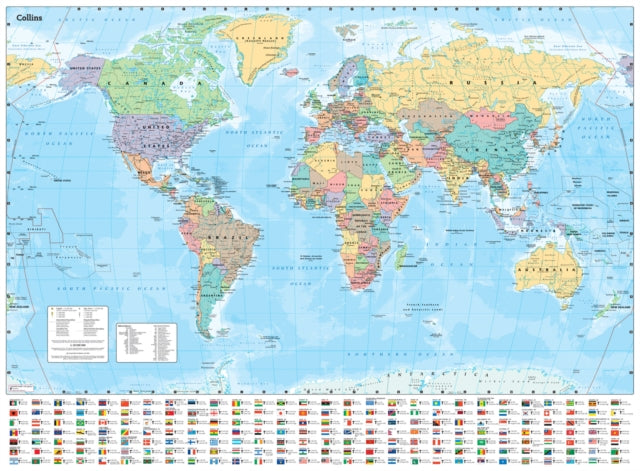
The Collins wall map is a comprehensive and up-to-date world map that includes political changes, major roads, cities, towns, national flags, and key statistics for every country. It is printed on high-quality paper and comes rolled in a recyclable cardboard box, making it ideal for classrooms, bedrooms, or offices. The map covers the entire world, centered on the Greenwich Meridian, and includes maps of the North and South Pole regions. It has a scale of 1:30 000 000 and a size of 700 x 951 mm (27.5 x 37.4 inches). There are also laminated flat map versions available.
Format: Sheet map, rolled
Publication date: 29 August 2024
Publisher: HarperCollins Publishers
Laminated flat map with stickers (ISBN 978-0-00-849255-7)
The Collins wall map is a comprehensive and up-to-date representation of the world, featuring a visually appealing and informative design. With its politically colored mapping, the map showcases each country and its capital city, major roads, and cities and towns in a clear and concise manner. Additionally, it includes national flags, key statistics for every country, and inset maps of the polar regions. Printed on high-quality paper and rolled in a fully recyclable cardboard box, the map is ideal for use as a poster in classrooms, bedrooms, or offices. Its area of coverage includes the entire world, centered on the Greenwich Meridian, and includes maps of the North and South Pole regions. The map's scale is 1:30,000,000, with 1 cm representing 300 km and 1 inch representing 480 miles. Its size is 700 x 951 mm (27.5 x 37.4 inches). The Collins wall map is available in two versions: a laminated flat map (ISBN 978-0-00-849254-0) and a laminated flat map with stickers (ISBN 978-0-00-849255-7).
Weight: 20g
Dimension: 700 x 915 x 50 (mm)
ISBN-13: 9780008712570
This item can be found in:
UK and International shipping information
UK and International shipping information
UK Delivery and returns information:
- Delivery within 2 - 3 days when ordering in the UK.
- Shipping fee for UK customers from £2.39. Fully tracked shipping service available.
- Returns policy: Return within 30 days of receipt for full refund.
International deliveries:
Shulph Ink now ships to Australia, Belgium, Canada, France, Germany, Ireland, Italy, India, Luxembourg Saudi Arabia, Singapore, Spain, Netherlands, New Zealand, United Arab Emirates, United States of America.
- Delivery times: within 5 - 10 days for international orders.
- Shipping fee: charges vary for overseas orders. Only tracked services are available for most international orders. Some countries have untracked shipping options.
- Customs charges: If ordering to addresses outside the United Kingdom, you may or may not incur additional customs and duties fees during local delivery.