Xploreit Maps,Mike Meagher
folded,Donegal Ireland: Xploreit County Map
folded,Donegal Ireland: Xploreit County Map
💎 Earn 65 Points (£0.65) on this item.
YOU SAVE £3.85
- Condition: Brand new
- UK Delivery times: Usually arrives within 2 - 3 working days
- UK Shipping: Fee starts at £2.39. Subject to product weight & dimension
Bulk ordering. Want 15 or more copies? Get a personalised quote and bigger discounts. Learn more about bulk orders.
Couldn't load pickup availability
- More about folded,Donegal Ireland: Xploreit County Map
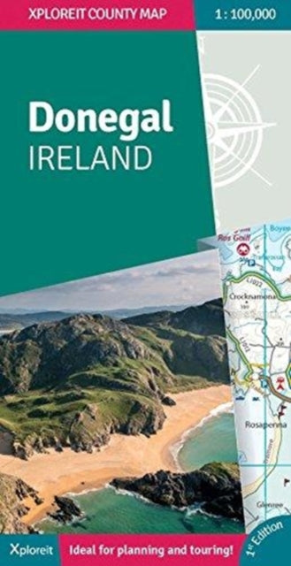
This convenient and informative travel map is specifically designed for visitors to Donegal. With a heady mix of peninsulas, promontories and sandy beaches, it has some of the most spectacular scenery in Ireland. Further inland, the attractions are just as enticing and include Glenveagh National Park - an all-time favourite destination.
Format: Sheet map, folded
Publication date: 31 January 2018
Publisher: Fountain Software and Publications Ltd
Xploreit Maps is an Irish publisher of maps and atlases, known for its comprehensive coverage of various regions. One of its notable series is the Xploreit County Series, which focuses on the western coastal counties of Ireland. This map, specifically dedicated to County Donegal, showcases a wealth of information for outdoor enthusiasts and travelers. It provides detailed maps of local and long-distance walking trails, cycle routes, and scenic drives, allowing visitors to explore the stunning landscapes of Donegal. The road network is extensively depicted, with driving distances indicated on the main routes. Parking spots, passenger ferry routes, harbors, and local piers are all included, making it convenient for travelers to plan their journeys. Woodland areas, mountains, rivers, and lakes are clearly marked, providing a visual reference for outdoor enthusiasts. Additionally, a large set of symbols is employed to illustrate a wide range of local points of interest, including antiquities, golf courses, museums, heritage centers, beaches for surfing and swimming, campsites, caravan parks, and many more. This map serves as a valuable tool for planning trips to County Donegal and exploring its diverse attractions.
Weight: 132g
Dimension: 260 x 140 x 9 (mm)
ISBN-13: 9780955265587
This item can be found in:
UK and International shipping information
UK and International shipping information
UK Delivery and returns information:
- Delivery within 2 - 3 days when ordering in the UK.
- Shipping fee for UK customers from £2.39. Fully tracked shipping service available.
- Returns policy: Return within 30 days of receipt for full refund.
International deliveries:
Shulph Ink now ships to Australia, Belgium, Canada, France, Germany, Ireland, Italy, India, Luxembourg Saudi Arabia, Singapore, Spain, Netherlands, New Zealand, United Arab Emirates, United States of America.
- Delivery times: within 5 - 10 days for international orders.
- Shipping fee: charges vary for overseas orders. Only tracked services are available for most international orders. Some countries have untracked shipping options.
- Customs charges: If ordering to addresses outside the United Kingdom, you may or may not incur additional customs and duties fees during local delivery.