Mark Richards
Hadrian's Wall Path Map Booklet: 1:25,000 OS Route Mapping
Hadrian's Wall Path Map Booklet: 1:25,000 OS Route Mapping
💎 Earn 47 Points (£0.47) on this item.
YOU SAVE £3.47
- Condition: Brand new
- UK Delivery times: Usually arrives within 2 - 3 working days
- UK Shipping: Fee starts at £2.39. Subject to product weight & dimension
Bulk ordering. Want 15 or more copies? Get a personalised quote and bigger discounts. Learn more about bulk orders.
Couldn't load pickup availability
- More about Hadrian's Wall Path Map Booklet: 1:25,000 OS Route Mapping
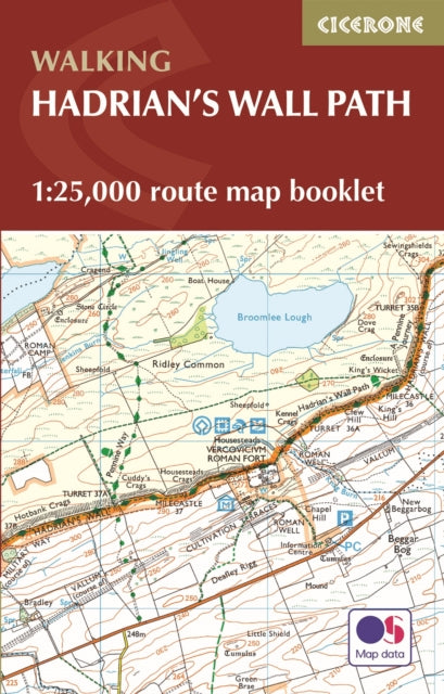
This booklet contains Ordnance Survey 1:25,000 Explorer maps of the Hadrian's Wall Path, designed for convenient use on the trail. It shows the full and up-to-date line of the path, along with relevant extract from the OS Explorer map legend, and is conveniently sized for slipping into a jacket pocket or rucksack. It is included with the Cicerone guidebook to Hadrian's Wall Path National Trail.
Format: Paperback / softback
Length: 56 pages
Publication date: 07 August 2023
Publisher: Cicerone Press
All the mapping you need to walk the 84-mile (135km) Hadrian's Wall Path from Bowness-on-Solway in Cumbria to Wallsend, Newcastle. This booklet of Ordnance Survey 1:25,000 Explorer maps has been designed for convenient use on the trail. It shows the full and up-to-date line of the Hadrian's Wall Path, along with the relevant extract from the OS Explorer map legend. It can be used when walking the trail west-east or east-west, and includes an extension to the east coast at South Shields. It is conveniently sized for slipping into a jacket pocket or top of a rucksack. This booklet is included with the Cicerone guidebook to Hadrian's Wall Path National Trail.
All the mapping you need to walk the 84-mile (135km) Hadrian's Wall Path from Bowness-on-Solway in Cumbria to Wallsend, Newcastle. This booklet of Ordnance Survey 1:25,000 Explorer maps has been designed for convenient use on the trail. It shows the full and up-to-date line of the Hadrian's Wall Path, along with the relevant extract from the OS Explorer map legend. It can be used when walking the trail west-east or east-west, and includes an extension to the east coast at South Shields. It is conveniently sized for slipping into a jacket pocket or top of a rucksack. This booklet is included with the Cicerone guidebook to Hadrian's Wall Path National Trail.
Weight: 62g
Dimension: 106 x 166 x 5 (mm)
ISBN-13: 9781786311511
Edition number: 2 Revised edition
This item can be found in:
UK and International shipping information
UK and International shipping information
UK Delivery and returns information:
- Delivery within 2 - 3 days when ordering in the UK.
- Shipping fee for UK customers from £2.39. Fully tracked shipping service available.
- Returns policy: Return within 30 days of receipt for full refund.
International deliveries:
Shulph Ink now ships to Australia, Belgium, Canada, France, Germany, Ireland, Italy, India, Luxembourg Saudi Arabia, Singapore, Spain, Netherlands, New Zealand, United Arab Emirates, United States of America.
- Delivery times: within 5 - 10 days for international orders.
- Shipping fee: charges vary for overseas orders. Only tracked services are available for most international orders. Some countries have untracked shipping options.
- Customs charges: If ordering to addresses outside the United Kingdom, you may or may not incur additional customs and duties fees during local delivery.