Imray Imray
Imray Chart C31: Dover Strait to Le Havre
Imray Chart C31: Dover Strait to Le Havre
💎 Earn 112 Points (£1.12) on this item.
YOU SAVE £6.55
- Condition: Brand new
- UK Delivery times: Usually arrives within 2 - 3 working days
- UK Shipping: Fee starts at £2.39. Subject to product weight & dimension
Bulk ordering. Want 15 or more copies? Get a personalised quote and bigger discounts. Learn more about bulk orders.
Couldn't load pickup availability
- More about Imray Chart C31: Dover Strait to Le Havre
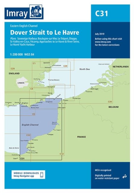
Several harbors and approaches in France are shown on the map, including Sovereign Harbour, Boulogne-sur-Mer, Le Treport, Dieppe, St-Valery-en-Caux, Fecamp, and the Le Havre Yacht Harbour.
Format: Paperback / softback
Length: 1 pages
Publication date: 12 March 2019
Publisher: Imray, Laurie, Norie & Wilson Ltd
Sovereign Harbour (1:20 000)
Boulogne-sur-Mer (1:25 000)
Le Treport (1:17 500)
Dieppe (1:17 500)
St-Valery-en-Caux (1:12 500)
Fecamp (1:15 000)
Approaches to Le Havre & River Seine (1:100 000)
Le Havre Yacht Harbour (1:10 000)
Sovereign Harbour, located at 1:20 000 scale, is a prominent feature on the map. It is situated in Boulogne-sur-Mer and is depicted with remarkable detail. The nearby Le Treport, at 1:17 500 scale, is also showcased, showing its intricate structures and surroundings. Dieppe, with its 1:17 500 scale representation, is depicted with its coastal lines and historical significance. St-Valery-en-Caux, at 1:12 500 scale, is shown with its charming coastal town and picturesque surroundings. Fecamp, at 1:15 000 scale, is depicted with its harbor and coastal defenses, highlighting its strategic importance. Moving further, the map showcases the Approaches to Le Havre & River Seine at a scale of 1:100 000. This section includes detailed representations of the harbors, including Le Havre Yacht Harbour, which is shown with incredible precision. Each of these locations is carefully depicted, providing a comprehensive view of the area's topography and geographical features. The level of detail and accuracy in these maps is impressive, making them valuable resources for researchers, historians, and anyone interested in exploring the region's history and geography.
Weight: 202g
Dimension: 238 x 330 x 8 (mm)
ISBN-13: 9781786791023
Edition number: New ed
This item can be found in:
UK and International shipping information
UK and International shipping information
UK Delivery and returns information:
- Delivery within 2 - 3 days when ordering in the UK.
- Shipping fee for UK customers from £2.39. Fully tracked shipping service available.
- Returns policy: Return within 30 days of receipt for full refund.
International deliveries:
Shulph Ink now ships to Australia, Belgium, Canada, France, Germany, Ireland, Italy, India, Luxembourg Saudi Arabia, Singapore, Spain, Netherlands, New Zealand, United Arab Emirates, United States of America.
- Delivery times: within 5 - 10 days for international orders.
- Shipping fee: charges vary for overseas orders. Only tracked services are available for most international orders. Some countries have untracked shipping options.
- Customs charges: If ordering to addresses outside the United Kingdom, you may or may not incur additional customs and duties fees during local delivery.