Collins Maps
Ireland Pocket Map: The Perfect Way to Explore Ireland
Ireland Pocket Map: The Perfect Way to Explore Ireland
💎 Earn 14 Points (£0.14) on this item.
YOU SAVE £1.15
- Condition: Brand new
- UK Delivery times: Usually arrives within 2 - 3 working days
- UK Shipping: Fee starts at £2.39. Subject to product weight & dimension
Bulk ordering. Want 15 or more copies? Get a personalised quote and bigger discounts. Learn more about bulk orders.
Couldn't load pickup availability
- More about Ireland Pocket Map: The Perfect Way to Explore Ireland
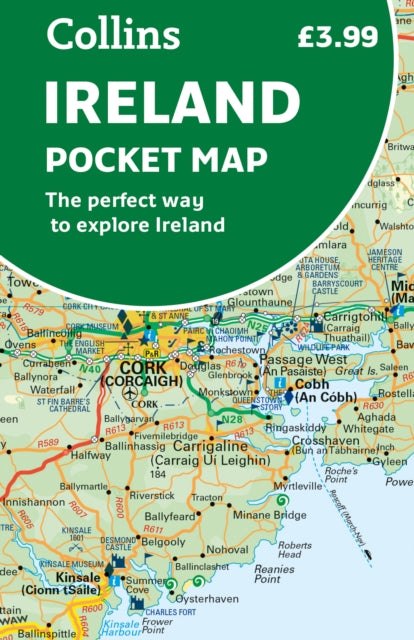
This map provides a comprehensive overview of Ireland, featuring detailed road changes, places of interest, ferry routes, and speed enforcement zones. With a scale of 1:470,000 and a size of 7.5 miles to 1 inch, it is ideal for travelers and is perfect for keeping in a pocket, bag, or glovebox.
Format: Sheet map, folded
Length: 2 pages
Publication date: 17 March 2022
Publisher: HarperCollins Publishers
Explore Ireland with this comprehensive and visually appealing full-color map. Designed to be both handy and affordable, this map offers a detailed representation of the entire country, including both the southern region up to and including Dublin and the northern areas beyond Dublin. Whether you're planning a road trip, exploring new destinations, or simply need a reliable map for reference, this product is an excellent choice.
The map is double-sided, featuring the south of Ireland on one side and the Dublin region on the other. This convenient design ensures that you can easily access the information you need, whether you're traveling through the southern part of the country or heading northward.
One of the key features of this map is its comprehensive coverage of road changes. It includes all the latest updates and modifications to road networks, making it an invaluable tool for navigating unfamiliar territory. Additionally, the map highlights various places of interest, such as landmarks, museums, and attractions, that are worth exploring during your visit to Ireland.
For those traveling by ferry, this map provides useful information on ferry routes and docking locations. It helps you plan your journey efficiently and ensures that you arrive at your destination on time. Moreover, the map includes speed enforcement zones and safety camera locations, which are essential for driving safely and adhering to traffic regulations.
With a scale of 1:470,000 and a distance measurement of 7.5 miles to 1 inch, this map offers precise and detailed mapping capabilities. It is designed to be easy to read and use, making it a valuable companion for any traveler. Whether you're a seasoned explorer or a first-time visitor to Ireland, this map will help you navigate with ease and discover all that this beautiful country has to offer.
Weight: 50g
Dimension: 140 x 90 (mm)
ISBN-13: 9780008412821
Edition number: New ed
This item can be found in:
UK and International shipping information
UK and International shipping information
UK Delivery and returns information:
- Delivery within 2 - 3 days when ordering in the UK.
- Shipping fee for UK customers from £2.39. Fully tracked shipping service available.
- Returns policy: Return within 30 days of receipt for full refund.
International deliveries:
Shulph Ink now ships to Australia, Belgium, Canada, France, Germany, Ireland, Italy, India, Luxembourg Saudi Arabia, Singapore, Spain, Netherlands, New Zealand, United Arab Emirates, United States of America.
- Delivery times: within 5 - 10 days for international orders.
- Shipping fee: charges vary for overseas orders. Only tracked services are available for most international orders. Some countries have untracked shipping options.
- Customs charges: If ordering to addresses outside the United Kingdom, you may or may not incur additional customs and duties fees during local delivery.